Following a storm that pummeled some areas of California with over a foot of rain, yards of snow and hurricane-force winds, another storm is forecast to move ashore this weekend for the same area. This next storm will have similarities, but it will also have some stark differences as well.
The storm that sat over California for the better part of this past week finally began to move away Friday, leaving impressive storm reports in its wake.


During Friday night, the storm quickly trekked across portions of Utah, Arizona, New Mexico, and Colorado.
However, there will be no rest for the weary as the next storm moves onto the West Coast.
“An influx of deep, moist air will stream into the West Coast this weekend and help to fuel rounds of heavy rain and heavy mountain snow,” said AccuWeather Meteorologist Mary Gilbert.
While rain and snow will again plague the West, there will be differences from the recently departed storm.
Although precipitation will be locally heavy, amounts will pale in comparison to the last storm. For example, Mammoth Mountain, California, received 107 inches of snow between Tuesday and Friday. With this next system, the highest totals are unlikely to be nearly that heavy. However, well over a foot of snow can fall, but it will likely be centered farther north in California. That is still more than enough snow to cause issues.
CLICK HERE FOR THE FREE ACCUWEATHER APP
“As this storm strengthens, it is likely that portions of major roadways will experience periodic shutdowns again,” cautioned Gilbert. “Heavy snow can reach down to pass levels for parts of Interstate 80 and may lead to spinouts and significant travel delays.”
Similarly, rainfall totals should not be as high. After over a foot of rain in some locations, rain is more likely to be measured in inches this weekend and into early next week.
Lastly, although high winds are expected, gusts are not forecast to be nearly as strong with this storm as compared to its predecessor. That said, with ground that is now saturated in many locations, winds will not need to be very strong to topple trees, as the softer and wetter ground is less stable than dry ground.
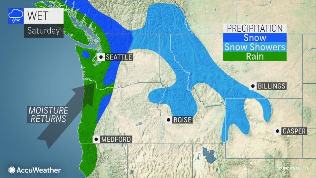
This next storm system will initially affect areas farther north. Washington and northern Oregon were largely spared this week, but that will not be the case this weekend. The heaviest rain is likely to fall right along the coast, but light to moderate rain will still dampen Interstate 5. In the Cascades, snow is expected to fall.

By Sunday night, the moisture will begin to aim farther southward. Even though it will not be as long-lasting, another atmospheric river may set up, this time aimed largely at Northern California.
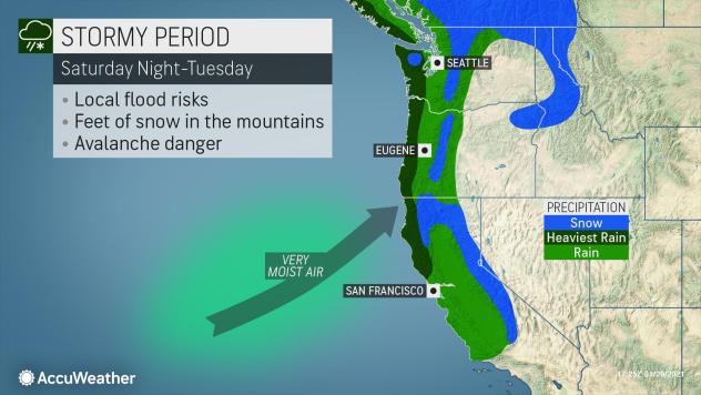
“The same areas that had to deal with disruptive weather from the most recent major storm may feel a sense of déjà vu this weekend into early next week,” said Gilbert. “Additional heavy rain at the coast will continue to help alleviate drought concerns, but the threat for hazardous mudslides will continue to loom large.”
By Tuesday, the rain and snow will slide southward into Central California. Precipitation should last 24 hours or less in that area, just a fraction of the time compared to this past week.
Once this next system departs, there is some question as to how long dry weather will last. Another system may move into Washington and Oregon Thursday, but there is a chance it will remain up in Canada. Either way, the areas of California that were most affected by this past week’s rain and snow as well as the upcoming event should experience several dry days.
***As certain voices are censored and free speech platforms shut down, be sure to sign up for CBN News emails and the CBN News app to ensure you keep receiving news from a Christian Perspective.***
The remainder of this article is available in its entirety at CBN