A wet and active weather pattern is set to return after only a brief two- to three-day hiatus to downpours in the southern United States in the coming week. The change in the weather will ignite all-too-familiar dangers like severe thunderstorms and flooding.
Only a select few locations across the South have had any reprieve from the rounds of wet weather so far this spring, while the rest have been deluged with rainy day after rainy day.
Since March 1, Jackson, Mississippi, has picked up 14.8 inches of rain, more than 135% of normal. In the same time frame, Nashville has received just under 18 inches of rain, which is 195% of normal. Even wetter, the city of New Orleans has measured more than 26 inches of rain since March 1, an impressive 260% percent of normal.
CLICK HERE FOR THE FREE ACCUWEATHER APP
Abundant rainfall has been helpful in keeping away drought conditions, which have plagued many other major cities across the U.S. such as Detroit, Chicago, San Francisco, Los Angeles and Phoenix, the pattern that has helped to unleash excessive rain has also triggered multiple flooding events and rounds of severe weather in the South.
Earlier this week alone, severe thunderstorms erupted across Tennessee, Mississippi and Alabama, leaving tens of thousands without power and forcing dozens of rescues amid rapidly rising floodwaters. Severe weather kicked into high gear right off the bat in May, as accurately predicted by AccuWeather meteorologists.
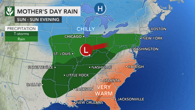
The next bout of both wet and severe weather will begin over Mother’s Day weekend. A storm will develop in the center of the country, where rain and severe weather are predicted to unfold across portions of Kansas, Oklahoma and Missouri.
These areas have not been hit as hard with rain as the Gulf Coast states have been so far this spring, but threats such as flooding downpours, large hail, damaging winds and isolated tornadoes will all be possible.
The storm will shift into more flood-weary areas on Sunday, as it spreads rain across the Ohio Valley, Tennessee Valley and parts of the Mississippi Valley.

Once again, severe weather will accompany the heaviest rain, threatening areas from western Tennessee and Mississippi to northeastern Texas.
AccuWeather forecasters expect hail and damaging winds to be the main severe weather impacts along with widespread torrential downpours.
The rounds of heavy rainfall this weekend are likely to dangerously reduce visibility for motorists, as well as cause ponding on the roadways. Those with outdoor plans should consider indoor alternatives in order to remain sheltered from the severe weather.

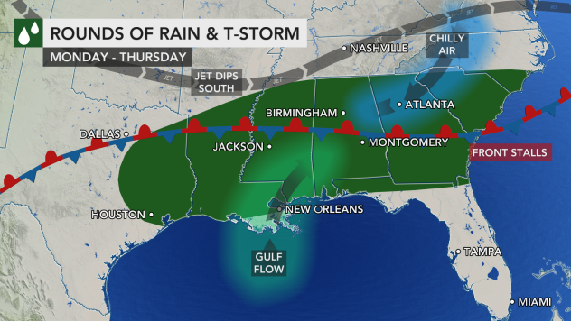
Once the weekend wraps up, even more rain is on the way for next week as several storms will push across the lower Mississippi River Valley and through the Southeast.
The storm from the weekend will slowly press across the Southeast through Monday night, and the next storm will already be strengthening in eastern Texas. This final slow-moving storm will spread from Texas to Georgia from Tuesday to Thursday, bringing days of rain to most locations.
“The repeated rounds of rain across the South could be heavy at times and lead to localized flooding issues from Louisiana to the Southeast Coast,” said AccuWeather Senior Meteorologist and Lead Long-Range Forecaster Paul Pastelok.

With several days of rain expected, widespread rainfall totals of 2-4 inches are forecast from eastern Texas to Mississippi and Alabama, with an AccuWeather Local StormMax™ of 10 inches possible.
According to Pastelok, heavier rain over the already saturated ground of Louisiana and Mississippi could lead to “significant flooding.”

This rain will also reach a few spots in the southeastern U.S. that have been on the drier side so far this spring, like North and South Carolina. Any rain will be beneficial in this zone, but rain could pour down quickly enough to lead to flooding concerns.
It is not out of the question that some severe weather could accompany the wet weather, as warm, moist conditions from the Gulf of Mexico will accompany the storms as they arrive across the Southeast. Other than flooding, the most likely threat would be damaging wind gusts.
There is a bit of light at the end of the tunnel, AccuWeather forecasters say. By the end of next week, an area of high pressure is expected to settle over the southeastern U.S. The weather system is likely to provide at least a couple days of dry weather during the middle of the month. The increased sunshine will help to warm things up as well.
***Please sign up for CBN Newsletters and download the CBN News app to ensure you keep receiving the latest news from a distinctly Christian perspective.***
The remainder of this article is available in its entirety at CBN


