Henri was moving northeast on Saturday morning, packing 70-mph sustained winds, after making a full turn to the north on Friday, and AccuWeather forecasters say the storm, set to strengthen into a hurricane, is on a collision course with Long Island, New York.
It’s been nearly 36 years since a hurricane delivered a direct hit to Long Island. The last hurricane to make landfall on Long Island was Gloria, when it came ashore as a Category 1 storm on Sept. 27, 1985. AccuWeather meteorologists urged those in the path of Henri to complete preparations for the storm as soon as possible as conditions were expected to begin deteriorating in less than 24 hours.
Henri is rated a 1 on the AccuWeather RealImpact™ Scale for Hurricanes in the United States due to the anticipated rainfall, damaging winds and storm surge set to impact Long Island and New England. As of early Saturday morning, according to the National Hurricane Center (NHC), Henri was swirling over the Atlantic about 200 miles east of Cape Hatteras, North Carolina and 525 miles south of Montauk Point, New York, which is the very end of Long Island.
The storm had picked up considerable forward speed by Saturday morning and was moving north-northeast at 12 mph, up from a slow 7-mph forward speed a day earlier. The storm had grown somewhat as well, with tropical-storm-force winds extending up to 115 miles out from the center. Around midweek, the storm was much more compact, with tropical-storm-force winds extending about 80 miles out from the center.
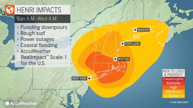
Hurricane warnings were issued by the National Hurricane Center (NHC) on Friday afternoon for many areas, including portions of Long Island, Connecticut and Rhode Island. Hurricane watches were in effect elsewhere, including southeastern Massachusetts. By Friday evening, tropical storm warnings were issued for much of southern New England, Long Island and southern New York, including New York City.
But, as of Saturday morning, the hurricane watches in effect for Martha’s Vineyard and Nantucket had been discontinued by the NHC. Martha’s Vineyard is instead under a tropical storm and storm surge warning. Nantucket is also under a storm surge warning.
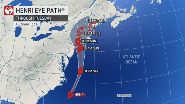
AccuWeather forecasters caution that impacts from Henri will be significant and calls for preparations ahead of the storm should be taken incredibly seriously. Henri is forecast to bring torrential downpours, strong wind gusts and inundating storm surge to coastal areas of the Northeast beginning early Sunday.
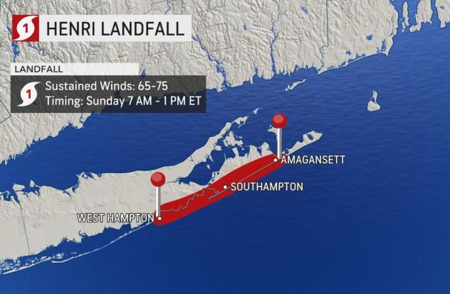
In terms of landfall, Henri is expected to come ashore along the eastern part of Long Island, between West Hampton and Amagansett. This includes a stretch of New York known as the Hamptons — home to some of the priciest real estate in the country. It is also a popular vacation spot for celebrities, many of whom have second homes there. Real estate is so valuable, there is an area that is nicknamed “billionaire’s lane.”
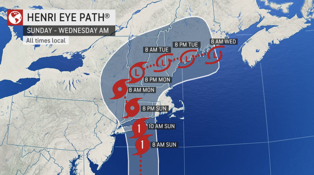
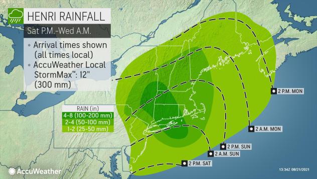
The heaviest rain is likely to fall just to the north and west of Henri’s exact track. Heavy rain will first arrive across Long Island and southern New England early Sunday morning before spreading over portions of New York and northern New England by Monday.
The heaviest rainfall of 4-8 inches with an AccuWeather Local StormMax™ of 12 inches will aim for the eastern tip of Long Island, parts of Connecticut, Rhode Island and western Massachusetts. For many New Englanders, Henri will be the first real brush with a hurricane in decades — and maybe ever for some.
“This is the most serious hurricane risk in New England in 30 years, since Hurricane Bob in 1991,” AccuWeather Chief Meteorologist and Senior Vice President of Weather Content and Forecast Operations Jon Porter said of the looming threat.
The drenching rainfall set to be unleashed by Henri comes just days after parts of the Northeast were soaked by Tropical Rainstorm Fred.
“Since Fred unloaded several inches of rain, Henri’s second dose of heavy, tropical rainfall may trigger flash flooding in the region more easily,” AccuWeather Senior Meteorologist Courtney Travis said.
The already saturated ground will also be a concern when it comes to Henri’s anticipated strong winds.
“In soggy, saturated ground, tree roots can lose their grip in the soil more easily due to the root system being compromised,” AccuWeather Meteorologist Reneé Duff explained. “As a result, it takes a much lower wind gust to knock over a tree sitting in wet soil as opposed to dry soil.”
CLICK HERE FOR THE FREE ACCUWEATHER APP
In addition, trees still have all of their leaves across much of southern New England, which can make them more easily weighed down by heavy rain and more susceptible to broken branches.
Strong winds are also going to be a threat as Henri strikes coast areas.
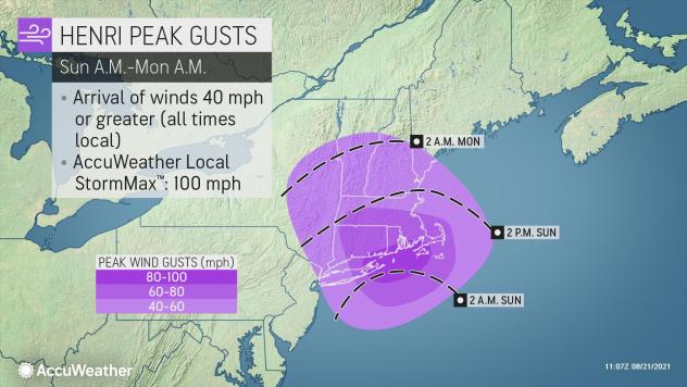
Widespread wind gusts of 40-60 mph are forecast to impact areas from Long Island to Maine from Sunday into Monday. The strongest winds with Henri will likely occur along and just east of the storm’s path. Wind gusts upwards of 80 mph with an AccuWeather Local StormMax™ of 100 mph are most likely from eastern Long Island into portions of eastern Connecticut and Rhode Island Sunday morning, largely in the hours surrounding landfall.
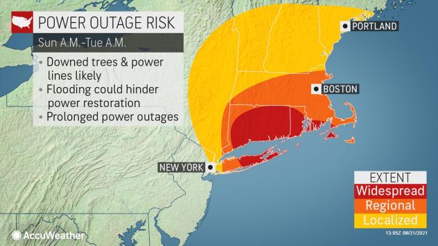
Winds of this magnitude will likely be enough to cause significant damage to trees, which can subsequently cause damage to power lines. AccuWeather forecasters are seriously concerned about the risk for widespread and perhaps prolonged power outages in the wake of Henri and the damage the storm is expected to cause.
On Friday, PSE&G Long Island warned in a press release that given the potential intensity of the storm, some resulting outages could last up to seven to 10 days, with the eastern end of Long Island expected to experience the most severe weather and impact.
Another significant risk with Henri will be its potential to produce a dangerous storm surge.
“Henri’s strong winds will funnel water into bays and inlets and raise the water level along the coast,” Travis said.
Henri’s arrival on Long Island will also coincide with a full moon on Sunday. This combination could bring higher tides and more widespread coastal flooding than what could occur during a different lunar phase.
A landfall earlier during the day on Sunday could make the situation more difficult, according to AccuWeather Broadcast Meteorologist Melissa Constanzer. Sunday’s high tide at Hampton Bays, which is between West Hampton and Southampton, will occur around 8:54 a.m. EDT, with the peak of the full moon on Sunday at 8:01 a.m. EDT.
“That will be an exaggerated high tide before landfall,” Constanzer warned.
Forecasters are currently anticipating Henri to make landfall in eastern Long Island during the late-morning hours of Sunday.
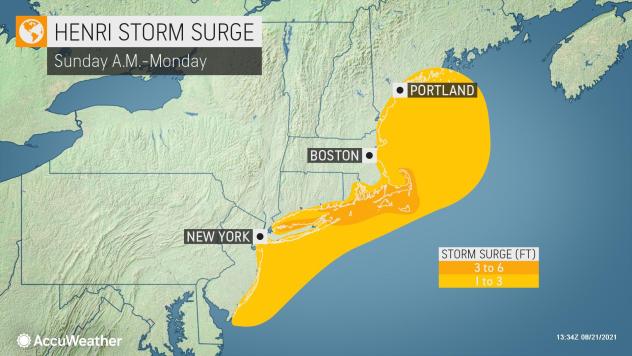
Storm surge of 1-3 feet is forecast to expand from the southern New Jersey coast to Maine, and a 3- to 6-foot storm surge is anticipated from eastern Long Island to Cape Cod.
AccuWeather forecasters further caution that impacts from Henri will not be confined to just the Northeast. The majority of the East Coast will experience some indirect impacts from Henri as the storm plows northward.
“Henri will remain offshore of the mid-Atlantic beaches as it moves northward through Saturday. Even still, beaches from Savannah, Georgia, to Atlantic City, New Jersey, can expect some indirect impacts from the storm,” Travis explained.
These impacts include, but are not limited to, rough surf and rip currents.
According to data from NOAA, more people have died as a result of rip currents on a yearly basis over the last decade than from lightning strikes or due to impacts from extreme cold combined.
AccuWeather meteorologists began warning that the Atlantic coast, including southern New England, would be at risk for tropical weather impacts this season in the annual fall forecast released in early August.
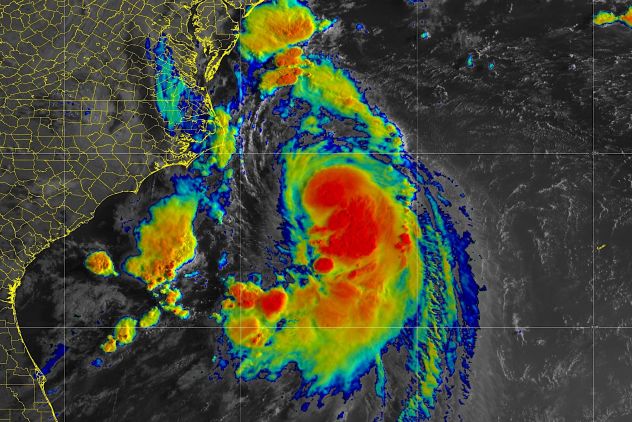
A satellite image showing Henri off the southeast coast of the U.S. early on Saturday, August 21, 2021. (NOAA)
Interestingly, the weather system that gave rise to Henri started out nearly two weeks ago as a cluster of thunderstorms over the middle of the continental U.S. That weather system raced across the country and headed out to sea over the Atlantic, where on Monday it formed into Tropical Storm Henri near Bermuda.
If Henri hits where AccuWeather forecasters are predicting, it will be the first hurricane in decades to make landfall on Long Island.
Gloria’s Long Island landfall in late September of 1985 was the storm’s second U.S. landfall after it hit the Outer Banks a day earlier. Gloria, which peaked at Category 4 force, had been billed by the media as “The Storm of the Century” but weakened considerably by the time it reached Long Island. When it struck western Lond Island, between John F. Kennedy International Airport and Islip, its forward speed was 40 mph and sustained winds were about 86 mph. Some 380,000 from North Carolina to Connecticut were evacuated ahead of Gloria.
Overall, Gloria was blamed for eight fatalities and $900 million in damages, about $2.2 billion in 2021 dollars.
Henri is forecast to continue north after striking Long Island and make a second landfall in New England. As long as Henri maintains its hurricane designation, as forecast, it will be only the eighth time a hurricane has struck New England since 1900.
The last hurricane to make landfall in New England was Bob in 1991. Bob made landfalls in Rhode Island and Maine and caused $1 billion in damage in Massachusetts. Winds greater than 100 mph and severe coastal flooding blasted Massachusetts during Bob’s rampage.
The remainder of this article is available in its entirety at CBN

